Gordon Brown wants to build 3 million houses, but there is nowhere to put some of them other than on flood plains. . . .
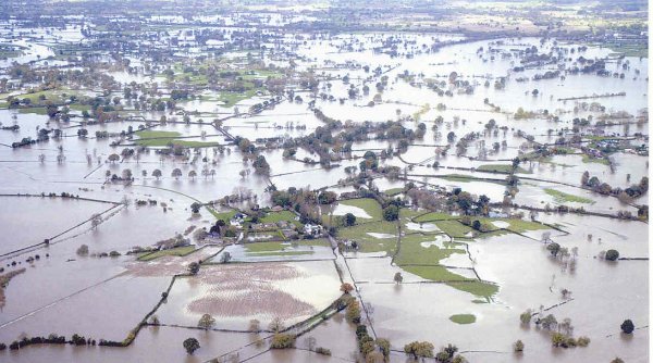
The widespread floods in 2006 and in 2007 brought misery to thousands mainly located in the Severn valley and Hull, resulting in huge claims on the insurance industry estimated at £3 billion. . . It is evident that if the sheer intensity of the rainfall is of an increasing frequency, then the current methods of erecting barriers, either temporary or permanent is inadequate and the pumping of excess water from tributaries is worthy of further study.
Water, water, every where,
Nor any drop to drink
(Samuel Taylor Coleridge, The Rime of the Ancient Mariner)
Gordon Brown wants to build 3 million houses, but there is nowhere to put some of them other than on flood plains. In the past the insurers, represented by the Association of British Insurers (ABI), insisted on flood prevention measures being in place or at least underway before agreeing to insure new properties on flood risk areas.
The widespread floods in 2006 and in 2007 brought misery to thousands mainly located in the Severn valley and Hull, resulting in huge claims on the insurance industry estimated at £3 billion. Families are left in temporary accommodation while a backlog of renovation work remains. Many fear that before the damage is repaired, further floods will repeat the problem, while by then their insurance will be withdrawn or subject to massive excesses. Once desirable houses are virtually unsaleable.
If the frequency of heavy rain and its intensity has indeed increased due to global warming, radical solutions for housing requirements and for flood prevention are needed. Even if the rainfall pattern is quite normal, the progressive reduction in the natural absorption ability of the land by covering it with houses and access roads means that some prevention technology is now a necessity.
How can individual houses be flood proofed?
There are solutions for individual houses that can be made, assuming, quite reasonably, that government measures will always be inadequate.
• Houses can be made to float by being constructed in concrete tanks, so that they simply rise above the flood.
• They can be raised on piled "stilts" or "legs".
• Isolated farmhouses can be provided with an all-round bank with water-tight access gates.
For more traditionally designed houses, electrical consumer units and gas meters can be mounted on the first floors, where appliances such as boilers can be located. Toilets, baths and sinks located on upper floors would also be secured from rising sewage levels. Ground floor toilets can be fitted with one-way valves. A whole industry has emerged supplying barriers and equipment for individual houses. Instead of drives, perforated concrete modules can be laid with drainage holes allowing water through, but access roads draining into storm water mains add to nearby river flows.
In most cases flooded houses are simply restored to their original state, whereas the insurance money could be used to move kitchens and living accommodation to the first floor, then providing loft extensions to replace lost bedrooms and bathrooms.
The problem is that once an area is developed for housing or industrial buildings, the natural absorption carrying capacity of a floodplain is reduced, causing run-off into swollen rivers. Water that would have lain on the plain or soaked into the ground ends up in the river and floods other areas further downstream.
Where there is no remembered history of flooding householders are taken unawares and are left with inadequate measures like sandbagging. Although there are now flood warnings, effective prevention needs planning and investment.
 What
is done by the authorities?
What
is done by the authorities?
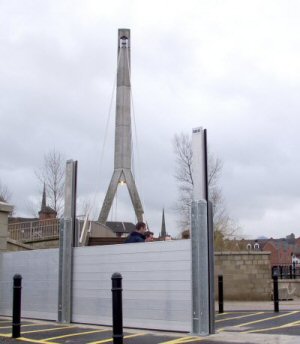
In the past sides of rivers have been raised with banks constraining the flow within them. Recently temporary barriers have been erected where floods have occurred in the past (and were prevented from reaching the community to be protected by floods intervening between the store and the application!).
River bends are often by-passed by drainage "cuts", which are usually a straight channel connecting the start and finish of the bends.
Banks, barriers and cuts, while protecting the object for which they were intended, simply pass the water further downstream where it floods areas previously not affected.
If housing is located on a flood plain and the associated river banks are raised to protect it, the water which would otherwise have covered the flood plain goes downstream and floods perhaps other housing.
Local authorities can be blinkered by the political aim of providing housing for their constituencies. An example of a problem in the making is the proposed new town of Northstowe near Oakington in Cambridgeshire. Being on the fens, all suitable locations studied for the new town turned out to be subject to flooding, so the final location selected was removed from the at-risk maps and a system of two dry ponds and a dyke added as a preventative measure. [1] So if the ponds are left unemptied after rainfall, the next deluge will cause a flood. The provision of a suitable pumping station is not mentioned in the consultation documents at the last reading, so it is difficult to envisage how the proposed flood defence will work.
However, the idea of diverting flood water by pumping elsewhere led to the concept described below. The problem in Hull was that previous studies recommending more pumping capacity had not been implemented and one of the pumping stations was subject to intermittent failure by the flood it was supposed to control. [2] The problem was caused by an abnormal rainfall and if this pattern is to be repeated and as the city lies below sea level, increased pumping is urgently needed.
Marginal water diversion
In 2006 and in 2007 there were severe floods in the Lower Severn arising from deluges on the Welsh hills reaching the Upper Severn tributaries. Also in the Lower Severn catchment area, eight weather stations in Gloucestershire, Worcestershire and Herefordshire had their wettest July on record in 2007, with Pershore College experiencing 252,4 mm (9.9") over the month, of which 157.4 mm (6.2") fell in two days and of which 120.8 mm (4.76") fell in one day. {3]
Although random downpours appear to be happening in the lower catchment area, the main mechanism is the precipitation as Atlantic rain clouds pass the Welsh hills. Also the flow in the main river is clearly the aggregate of the flows from the many tributaries. In flood at Worcester, the flow could be a massive 5000 m3/second, but what actually overflows the banks and barriers is a margin of this, as most of it stays in the river.
The concept is that if in times of high precipitation in the Welsh hills, water could be extracted from the main tributaries and pumped over passes via pipelines ending in the Irish Sea, the marginal quantity of water which would otherwise flood areas in the Lower Severn could be diverted. Even if this failed to prevent some flooding, whatever water is removed nearer its sources, will not come over the barriers, alleviating the floods.
If some of the excess flow from the tributaries could be removed over during the whole time that the flow in an individual tributary exceeds the average it would lower the level of the main river somewhat allowing it to carry rainfall from the sort of localised flooding that occurred at Pershore. [3]
There are ecological arguments for not transferring water to neighbouring rivers as species in one river should not be transferred to another. Contamination of a tributary is less harmful if released into the main river where the flow would reduce the concentration rather than contaminate another tributary. As the tributary eventually releases its contents into the sea, routing excess water to an estuary is a reasonable solution. Undesirable fresh-water organisms would presumably not survive in seawater. In any case neighbouring tributaries are likely to experience excess flow from the same precipitation source and might be flooded if water was added from another.
A practical example has been studied in order to consider whether the concept has merit.
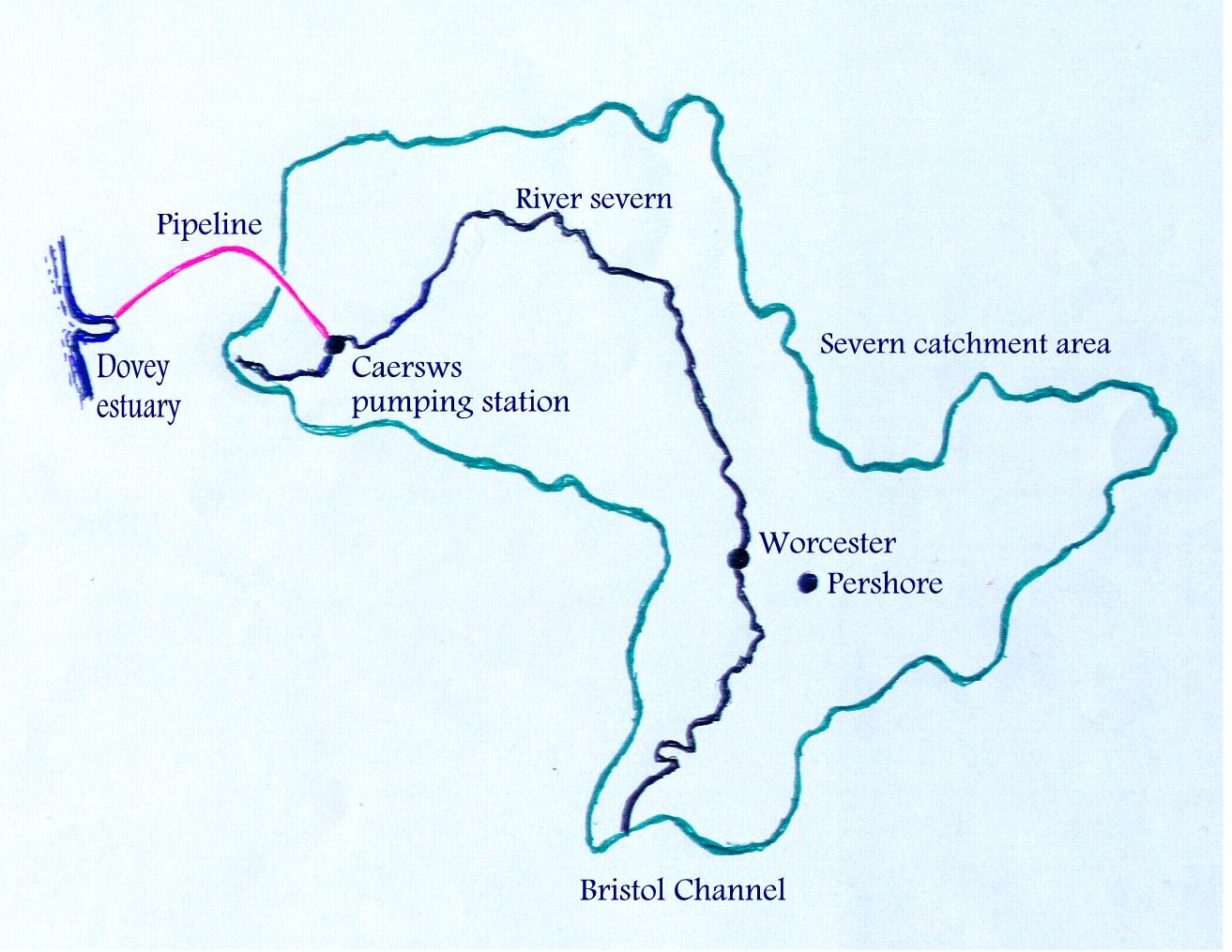
Caersws pumping station
The Environment Agency provided flow data [4] for the Upper Severn at Abermule (GR 165 958)* which showed a wide variation in daily maximum flow from 1 m3/second to over 200 m3/s, which occurred on 10 January 2008. The daily mean flow from 1969 to 2008 is 14.8 m3/s, so that the proposal is to pump 10 m3/s away at times when the flow exceeds its average, which occurred every day in January 2008, the mean flow being 50.6 m3/s. A surge in early December 2006 preceded the disastrous floods later in the month downstream.
The extraction point could be located to the West of Newtown at Caersws (GR 032 918) just below the confluence of the Afon Trannon and the Severn. This provides access to the railway which conveniently runs over the pass at Talerddig en route to Machynlleth and Dovey Junction by the estuary. This is a great advantage as the railway can carry the pipe sections as well as providing a non-controversial 40 km route for the pipeline. [5]
The pumping rate of 10 m3/s will need a pipe of 1.4 m diameter and the friction head is around 700 m. The static head is minus 100m as the lift to the pass of 100 m will be followed by a down leg to Dovey Junction 200 m below, so that the net pumping head is around 600m. The electricity supply to the pumping station will be around 100 MW.
It was tempting to think that because the down leg was twice the height of the up leg that some of the pumping energy as hydropower could be recovered at the sea outlet, but this would simply provide a back pressure adding to the extraction pump input energy.
The cost of the pipeline and pumping station is estimated at £200 million. If say another 4 tributaries of the Severn were to be equipped in the same way, perhaps 50 m3/s of excess water could be extracted. Although this amounts to but 1% of the Severn flow in flood, whatever is extracted would not go over the barriers further down. An expenditure of £1 billion would potentially save double that in remedial work for just one flood.
 Integration
with wind power
Integration
with wind power
The Carno wind farm on Trannon Moor is around 12 km WNW of Caersws (GR 915 955) and claims for the moment to have the largest production capacity in the UK of 600 MW. It is quite likely that winds reaching the wind farm might also bring the rainfall which leads to the excess water in the Upper Severn. The power to pump this water away might well be available from the wind farm when needed.
If a suitable location for a reservoir in the neighbourhood of the wind farm could be found the water pumped from the river could be stored in it for subsequent release through a hydropower station located at Dovey Junction or could be returned to the original extraction point at times when flow is below the average. The source valley of the Afon Cledau (GR 955 928) might provide a suitable location for a reservoir.
A criticism of wind power is its variability, which could be compensated by the integration with flood control and pumped storage, as was once arranged to compensate for the non-variability of nuclear power.
Universal applicability
The Severn catchment area is somewhat unique in being so large and adjacent to the Irish Sea. However, the principle of removing excess water from a river system near to its sources to reduce, even marginally, the flow reaching the areas often subject to floods could have universal application. It might even be possible in areas like the fens to use a siphon effect in the pipelines where the rise is less than 8 metres.
It is evident that if the sheer intensity of the rainfall is of an increasing frequency, then the current methods of erecting barriers, either temporary or permanent is inadequate and the pumping of excess water from tributaries is worthy of further study.
National water grid
The scheme would form part of a multi-purpose national water grid for flood control, wind power pumped storage and for irrigation of farmland and gardens otherwise in drought and subject to hosepipe bans, to fix the most carbon when temperatures rise.
[1] http://www.scambs.gov.uk/admin/documents/retrieve.asp?pk_document=905693 Page 62
Northstowe is a candidate for one of the 10 locations to be selected for the establishment of Eco-Towns. As an innovative town, the buildings could all be piled on "legs" with raised walkways. Once the old runways have been lifted and the ground scarified the natural drainage might be restored and maintained by the use of "concrete grass" for access roads. Services could be raised on pipe tracks (as in a chemical works) so that no retrospective ground works are required and which would damage the restored drainage property. A urban tramway could also be used for public transport and this could be elevated to avoid ground disturbance.
[2] http://www.hull.ac.uk/geog/PDF/floodsinhull2.pdf
[3] http://www.metoffice.gov.uk/climate/uk/interesting/july2007/index.html
[4] http://www.environment-agency.gov.uk File ABERMULE FQ MAX.all on Excel.
[5] See OS Landranger Maps 136 and 135
* GR = Grid reference